Log in
All resources
Create a design
263 Free Artworks of Old Maps Of The World
bibliothèque nationale de france
atlas novus (blaeu)
propaganda map
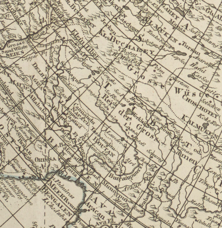
old maps of asia
1529 maps
1520s maps of the caucasus
old hemisphere world maps (partner files)
1529 maps of iran
latin-language maps
1800s maps of the world
diego gutiérrez
renaissance
maps by jacques-nicolas bellin
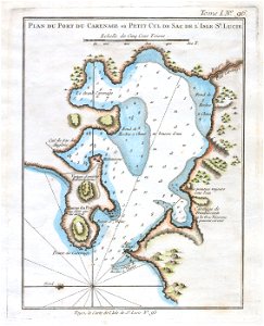
old maps of saint lucia
german empire
east germany
old maps of the british empire
illustrations by walter crane
maps by willem and johannes blaeu
old maps with mercator projection
maps by thomas kitchin
andrew dury
details of old maps of the world showing "aquita" in japan
johannes baptista vrints
fra mauro map details
old maps of thailand
1800s maps of the world
old maps of the world
claes jansz. visscher (ii)
1650s maps of the world
alphabet charts
lord's prayer
island of california on world maps
1650s maps of the world
1510s maps of the world
german renaissance
maps by willem and johannes blaeu
1630s maps of the world
russian empire in thomas kitchen's general atlas (1773)
general atlas (1773)
old maps of the sea of japan
rangaku
1590s maps of the world
cornelis de jode
orbispictus - extracted images
1650s maps of the world
maps by john cary
1801 maps
atlas ou representation du monde universel t. 2 (1633)
maps by jan janssonius
17th-century double hemisphere world maps
1610s maps of the world
19th-century satirical maps
augusto grossi
reconstructions of old maps
german renaissance
reconstructions of old maps
german renaissance
tresor des cartes geographiques (1659)
old maps of the benelux
1645 maps of belgium
tournaisis
island of california on world maps
1680s maps of the world
old maps of the eastern hemisphere
1710s maps of the world
19th-century maps of tibet
details of old maps
orbispictus - extracted images
1650s maps of the world
wilhelm pleydenwurff
hartmann schedel
old maps of the british empire
illustrations by walter crane
1529 maps of iran
1529 maps
maps of exeter by braun & hogenberg
hooker (alias vowell) arms
tresor des cartes geographiques (1659)
old maps of tunis
cartes generales de toutes les parties du monde (1658)
maps by guillaume sanson
maps from the earth and its inhabitants, vol. x
old maps of the world
old maps of the british empire
illustrations by walter crane
typus orbis terrarum
1570 maps of asia
19th-century maps of greece
pierre françois tardieu
1850s maps of the americas
maps by john tallis
1610s maps of the netherlands
old maps of friesland
tresor des cartes geographiques (1659)
old maps of the whole peloponnese
old maps of duchy of troppau
maps of duchy of jagerndorf
cornelius aurelius world map
ptolemaic taprobana
old maps of trinidad and tobago
17th-century maps of venezuela
maps by john cary
1799 maps
nicolas desmarest
ambroise tardieu
codex arundel (c.1480-1518) - bl arundel ms 263
sketches of the moon
1529 maps of iran
1529 maps
1529 maps of iran
1529 maps
1529 maps of iran
1529 maps
1529 maps of iran
1529 maps
16th-century maps of the middle east
propaganda map
1529 maps of iran
1529 maps
old maps of former departments of france
maps from gallica
old maps of former departments of france
maps from gallica
old administrative maps of the ottoman empire
1909 maps of asia
old hemisphere world maps (partner files)
arnold's geographical handbook (1899)
description de l'universe
1680s maps of the world
old maps of the eastern hemisphere
1710s maps of the world
1770s maps of alaska
robert de vaugondy
coats of arms of the kingdom of navarre
coats of arms of the crown of aragon
old maps of nassau
salomon rogiers
old maps of the eastern hemisphere
1710s maps of the world
old maps of the northern hemisphere
1800s maps of the world
old maps of southeast asia
maps by thomas starling
details of old maps
michael burghers
propaganda map
1529 maps
maps of prince-bishopric of münster
prince-bishopric of osnabrück
old hemisphere world maps (partner files)
arnold's geographical handbook (1899)
propaganda map
1529 maps
map collection of leibniz-institut für länderkunde
1800s maps of the world
old hemisphere world maps (partner files)
1800s maps of the world
maps by thomas kitchin
1781 maps of europe
old maps of veliky novgorod
maps of velikiy novgorod
maps by alexis-hubert jaillot
old maps of the tyrol
old maps of westphalia
bindenschild
old maps of the county of ravensberg
burg limberg
maps by willem and johannes blaeu
1630s maps of the world
old maps of salvador (bahia)
jacob van meurs
riga in the 17th century
old maps of riga
maps by pieter van der keere
old maps of gelderland
redeeming the republic (1890)
1890s maps showing history
atlas ou representation du monde universel t. 2 (1633)
old maps of the republic of genoa
a system of modern geography (1810)
old maps of the holy land
a system of modern geography (1810)
old maps of the holy land
1840s maps showing history
maps by thomas starling
atlas, ou représentation du monde universel et des parties d'icelui, faicte en tables et descriptions très amples et exactes, divisé en deux tomes. édition nouvelle... - btv1b53103889w
maps facing west
old maps of the eastern hemisphere
1680s maps of the world
old maps of the sinai peninsula
1870s maps of palestine
lehen (freiburg im breisgau)
baroque
maps in the library of congress
old maps of antigua and barbuda
1727 maps of africa
1720s maps of egypt
everett d. graff collection of western americana
george f. cram
maps by thomas starling
1842 maps
old maps of regions of france
pierre françois tardieu
old maps of ukraine
atlas novus (blaeu)
old maps of the western hemisphere
jacob van meurs
atlas ou representation du monde universel t. 2 (1633)
maps by hendrik hondius the younger
101 - 200 of 263
Next page
/ 3


![Gerardi Mercatoris and I. Hondii Atlas or Representation of the Universal World, and of the Parts of It, Made in Tables and Very Ample Descriptions. [t. 2].](https://cdn.creazilla.com/illustrations/10001063637/gerardi-mercatoris-and-i-hondii-atlas-or-representation-of-the-universal-world-and-of-the-parts-of-it-made-in-tables-and-very-ample-descriptions-t-2-sm.webp)


![[Reproduction of the terrestrial globe (orbis imago) by Jean Stabius, 1515] (Facsimile reproduction)](https://cdn.creazilla.com/illustrations/10000781714/reproduction-of-the-terrestrial-globe-orbis-imago-by-jean-stabius-1515-facsimile-reproduction-sm.webp)
![[Reproduction of the terrestrial globe (orbis imago) by Jean Stabius, 1515] (Facsimile reproduction)](https://cdn.creazilla.com/illustrations/10000450806/reproduction-of-the-terrestrial-globe-orbis-imago-by-jean-stabius-1515-facsimile-reproduction-sm.jpg)
![Treasure of geographical maps of the main states of the universe [...], 1659](https://cdn.creazilla.com/illustrations/10000541161/treasure-of-geographical-maps-of-the-main-states-of-the-universe-1659-md.jpg)


![Treasure of geographical maps of the main states of the universe [...], 1659](https://cdn.creazilla.com/illustrations/10000832962/treasure-of-geographical-maps-of-the-main-states-of-the-universe-1659-md.jpg)


![Treasure of geographical maps of the main states of the universe [...], 1659](https://cdn.creazilla.com/illustrations/10000206928/treasure-of-geographical-maps-of-the-main-states-of-the-universe-1659-md.jpg)


![Topographical Map of the Department of Montenotte / Written by the care of Mr. Count de Chabrol Prefect. Scale of 10,000 Meters [=Om. 050; 1: 200,000]; Drawn by Cecchi, geographer, between 1806 and 1812](https://cdn.creazilla.com/illustrations/10000886036/topographical-map-of-the-department-of-montenotte-written-by-the-care-of-mr-count-de-chabrol-prefect-scale-of-10-000-meters-om-050-1-200-000-drawn-by-cecchi-geographer-between-1806-and-1812-sm.jpg)
![Topographical Map of the Department of Montenotte / Written by the care of Mr. Count de Chabrol Prefect. Scale of 10,000 Meters [=Om. 050; 1: 200,000]; Drawn by Cecchi, geographer, between 1806 and 1812](https://cdn.creazilla.com/illustrations/10000562582/topographical-map-of-the-department-of-montenotte-written-by-the-care-of-mr-count-de-chabrol-prefect-scale-of-10000-meters-om-050-1-200000-drawn-by-cecchi-geographer-between-1806-and-1812-sm.webp)


![Gerardi Mercatoris and I. Hondii Atlas or Representation of the Universal World, and of the Parts of It, Made in Tables and Very Ample Descriptions. [t. 2].](https://cdn.creazilla.com/illustrations/10000735247/gerardi-mercatoris-and-i-hondii-atlas-or-representation-of-the-universal-world-and-of-the-parts-of-it-made-in-tables-and-very-ample-descriptions-t-2-sm.webp)


![Gerardi Mercatoris and I. Hondii Atlas or Representation of the Universal World, and of the Parts of It, Made in Tables and Very Ample Descriptions. [t. 2].](https://cdn.creazilla.com/illustrations/10000421870/gerardi-mercatoris-and-i-hondii-atlas-or-representation-of-the-universal-world-and-of-the-parts-of-it-made-in-tables-and-very-ample-descriptions-t-2-sm.jpg)